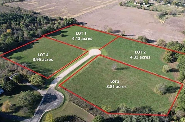
Boundary surveys play a crucial role in real estate transactions and property management. They provide property owners with an accurate understanding of their land’s boundaries, helping to protect property rights and avoid disputes with neighbors.
This article delves into the significance of boundary surveys, the processes involved, and the benefits they provide to property owners.
What is a Boundary Survey?
A boundary survey is a precise measurement of a parcel of land, establishing its boundaries and identifying any easements, encroachments, or rights-of-way. Conducted by licensed surveyors, these surveys are essential for property owners, buyers, and developers to ascertain their legal rights concerning land use and ownership.
The Importance of Boundary Surveys
1. Protecting Property Rights
Understanding the exact boundaries of your property is vital for asserting your property rights. A boundary survey provides clear documentation of where your property begins and ends, ensuring that you can use and develop your land without encroaching on neighboring properties. This documentation is critical in legal disputes over property lines.
2. Preventing Disputes
Boundary disputes between neighbors can lead to costly legal battles. A boundary survey helps prevent these disputes by clearly marking property lines, which can reduce misunderstandings and conflicts. Having a professional survey done provides a neutral, factual basis for resolving disagreements.
3. Facilitating Real Estate Transactions
When buying or selling property, a boundary survey is often a requirement for closing the deal. It assures buyers of the exact boundaries of the property they are purchasing and can reveal any potential issues, such as encroachments or easements, that could affect the property’s value and usability.
4. Identifying Easements and Encroachments
Boundary surveys help identify any easements (legal rights to use someone else’s land for a specific purpose) or encroachments (intrusions on your property by a neighboring property). Knowing about these factors can impact property use and development plans and inform negotiations with neighbors.
5. Complying with Local Regulations
Many local governments require boundary surveys for building permits, zoning changes, and other development activities. Conducting a boundary survey ensures compliance with local laws and regulations, preventing delays in development projects.
The Boundary Survey Process
1. Hiring a Professional Surveyor
The first step in conducting a boundary survey is hiring a licensed professional surveyor. It’s essential to choose someone with experience and a good reputation in your area. They will assess your property’s specific needs and explain the process.
2. Research and Preparation
The surveyor will begin by researching public records, including property deeds and previous surveys. This research helps establish a clear understanding of the property’s history, which is vital for accurate measurements.
3. Field Work
Next, the surveyor conducts fieldwork to measure the property and mark its boundaries. This involves using specialized equipment like GPS, total stations, and leveling instruments to ensure precision. The surveyor will also inspect the land for physical markers, such as fences, trees, or monuments, that may indicate property lines.
4. Creating the Survey Map
After completing the fieldwork, the surveyor will create a detailed survey map, illustrating the property’s boundaries, dimensions, and any existing structures or features. This map may also highlight easements, encroachments, and zoning information.
5. Review and Certification
Once the map is complete, the surveyor will review it with you to explain the findings and ensure your understanding. After this review, the surveyor certifies the map, providing a legal document that can be used in real estate transactions and dispute resolutions.
Benefits of Boundary Surveys
1. Enhanced Property Value
A clear understanding of property boundaries can enhance your property’s value. It assures potential buyers of the land’s precise limits, making the property more attractive in the real estate market.
2. Informed Decision-Making
With accurate boundary information, property owners can make informed decisions about land use, development, and improvements. This knowledge allows for better planning and resource allocation.
3. Peace of Mind
Knowing that your property boundaries are well-defined provides peace of mind. You can enjoy your property without the constant worry of potential disputes or misunderstandings with neighbors.
Conclusion
Boundary surveys are essential tools for protecting property rights and ensuring legal compliance in real estate transactions.
By providing accurate and clear delineations of property lines, they help prevent disputes, facilitate smoother transactions, and enhance property value.
Engaging a qualified surveyor to conduct a boundary survey can safeguard your interests and provide peace of mind as a property owner.
Investing in this service is not only a wise decision but also a crucial step in maintaining your property’s integrity and your legal rights.
Also Read
From 2D to 3D: The evolution of surveying in modern construction
Precision matters: Exploring the latest technologies in land surveying

