By Peter Tapken
Increasing investments in large infrastructure and construction projects, and the rising role of building information modelling (BIM), are expected to drive the market for geospatial equipment.
BIM’s close connection with spatial information makes it a familiar landscape and offers rich possibilities for surveyors and other geospatial professionals. Geomares – publisher of ‘GIM International’ and ‘Geo-matching’ – has analysed the user data and behaviour of thousands of members of the global geospatial community.
It is interesting to see how the market of ‘traditional survey equipment’ such as total stations and terrestrial laser scanners will respond to the growing construction market and the digitalization of this area.
Total stations and terrestrial laser scanners have a wide variety of capabilities and are extensively exploited in cadastral surveying, civil engineering and on construction sites. Surveying professionals use a mix of advanced technologies such as aerial and terrestrial photogrammetry and Lidar, but traditional ground surveys remain vital components of any building project.
Data from global navigation satellite systems (GNSS) and total stations can be integrated with Lidar and photos to provide georeferencing and increased detail and precision. Despite the increased role of advanced technologies entering the geospatial world, market research states that the market outlook for total stations and terrestrial laser scanners is still very good.
Two important reasons why these markets will keep growing over the coming years are the increasing investments in the construction market and the rising role of BIM – after all, the construction industry is undergoing a major transition towards digitalization.
Rising Role of BIM in the Construction Sector
BIM is one of the most intriguing opportunities for surveyors to come along in years. BIM combines technologies and processes to support efficient creation and use of information for construction projects.
Because of their expertise with spatial information, surveyors and other geospatial professionals are well positioned to become trusted participants in BIM-based construction projects.
They can leverage their skills in 3D data management, modelling and visualization to support the ‘design, build and operate’ processes that lie at the core of BIM. Surveyors and other geospatial professionals would benefit from becoming highly skilled in BIM concepts and technologies that rely on spatial information so they can provide valuable services throughout a project’s development, construction and operation stages.
Laser scanning is the connecting point between geomatics and BIM because point clouds are very important for creating building information models. From a spatial data perspective, one of the critical values of BIM is its capability to represent buildings at a finer level of detail, making it especially helpful in representing building interiors. It is clear that the growing role of BIM in the construction sector will have a strong impact on the geospatial market and that geospatial equipment has a vital role in the building information modelling process.
Market Data Analysis
Of the 500,000 professionals that visited the GIM International and Geo-matching websites in 2018, a large percentage of them were interested in total stations and terrestrial laser scanners. This puts Geomares in a unique position to analyse website behaviour to discover trends and insights related to such products. The following overview is based on a combination of Geo-matching website data, Google search statistics and market research.

Behaviour of Geo-matching Users
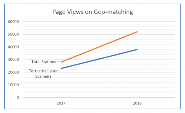
Total stations and terrestrial laser scanners are very important product categories of the Geo-matching website, with 120 products listed from 32 manufacturers. In 2018 there was strong growth in the number of page views for total stations with an 87% increase compared to 2017. Meanwhile, the number of page views for terrestrial laser scanners increased by 60% (see Figure 1). This indicates a rising demand for both geospatial data acquisition methods.
Market Forecasts for Total Stations and Terrestrial Laser Scanners
Surveying technologies, such as total stations and terrestrial laser scanners, are being adopted in a wide variety of application areas. Total stations are used for surveying, construction and engineering but also for transportation planning, forestry and land management, and for precision agriculture.
For agricultural tasks related to precision farming, accurate in-field positioning is a necessity. Robotic total stations are gaining a lot of attention in the agricultural sector due to their increased accuracy. These new applications are expected to further drive the market for total stations and terrestrial laser scanners, especially in the Asia-Pacific region.
Other growth factors include increased investments in the construction and infrastructure sector, and the rising role of BIM, especially in India, China and other countries in southern Asia. Initiatives for developing smart cities, and the corresponding need for BIM and geospatial technology, will further boost the market for total stations and terrestrial laser scanners. However, there are differences between both markets:
The total station market forecast
Market research states that the Asia-Pacific region holds the biggest market share for total stations globally. North America also holds a significant market share and the growth in the transportation and construction sectors in countries like the USA, Canada, and Mexico is expected to further expand the market.
The terrestrial laser scanner market forecast
The global market for terrestrial laser scanners is expected to grow over the coming years with Asia-Pacific anticipated to be the fastest growing region. The Asia-Pacific market is already the largest market, followed by North America and Europe.

Google Search Volume
The Google keyword planner was used to study the search volume for total stations and terrestrial laser scanners worldwide from 2015-2018 (see Figure 2).
Search volume for total stations and terrestrial laser scanners
Interestingly, the search volume for total stations and terrestrial laser scanners has stayed about the same in the last three years. For total stations there was a 15% increase in search volume from 2015 to 2018. For terrestrial laser scanners there was a 7% increase in search volume from 2015 to 2018.
Based on the market growth of total stations and terrestrial laser scanners this search volume growth is lower than expected when considering the overall market growth. One explanation for this could be that the market is already well established with an extensive dealer network worldwide.
In other words, interested buyers could already receive enough information about total stations and terrestrial laser scanners from manufacturers and dealers.
Profile of Typical Total Station Users
User surveys show that Geo-matching is primarily used as an information source and is important for product research. On Geo-matching, product specifications can be compared, users can read case studies/watch product videos and can contact product manufacturers directly.
The user behaviour provides interesting quantitative information and can show general trends. But the types of contact requests made through Geo-matching provide even greater insights into how, and for what purposes, total stations and terrestrial laser scanners are used.
The enquiries range from major organizations like national armies, universities, surveying and mapping companies, and precision agriculture service providers to large engineering and mining companies worldwide. A notably large number of the enquiries come from the Asia-Pacific region, which is in line with market research.

Regional Distribution of Geo-matching Users
Market research states that the market for total stations and terrestrial laser scanners will grow the fastest in the Asia-Pacific region the coming years. Geo-matching user statistics support these claims, but the number of users viewing total station pages, particularly from India, is much higher than expected.
Geographical distribution of total station users
The Asia-Pacific region, and India in particular, is by far the biggest group searching for total stations on Geo-matching (58% from Asia-Pacific, 14% from the Americas, 13% from Europe, 12% from Africa and 2% from Oceania).
Geographical distribution of terrestrial laser scanner users
Market research identifies North America as the dominant region in the market for terrestrial laser scanners, followed by Asia-Pacific and Europe. It is interesting to see that the Geo-matching user profile is in line with this. Most users are from the American regions (29%), followed by Europe (28%), Asia (28%), Africa (11%) and Oceania (3%).

Conclusion
The growing construction sector worldwide, the transition towards digitalization, and the increasing role of BIM provide great opportunities for the geospatial sector. Surveying professionals are very familiar with geospatial data and they can leverage their skills in 3D data management, modelling and visualization to support the ‘design, build and operate’ processes that lie at the core of BIM.
To support BIM processes, surveying professionals will need to use a mix of advanced geospatial technologies such as aerial and terrestrial photogrammetry and Lidar. Traditional ground survey equipment, such as total stations and terrestrial laser scanners, will however remain key components of any building project.
Terrestrial laser scanners are still the connection point between geomatics and BIM because point clouds are very important for creating building information models – especially for interior models.
Market research states that the Asia-Pacific region will invest over the coming years in large infrastructure projects, smart cities and advanced 3D modelling technology. These investments will drive demand in the geospatial market as a whole, and the total station and terrestrial laser scanner markets will also benefit from the geospatial market growth.
The market research findings are supported by Geo-matching user data. The Asia-Pacific region is the largest market for total stations and terrestrial lasers scanners and this market is still expected to grow. On Geo-matching, 50% of the total stations pages are from India and Bangladesh.
For terrestrial laser scanners pages, 25% is from India and Bangladesh. Geo-matching is primarily used for product research, so the strong interest in the Asia-Pacific region could be a clear indicator of a growing market there in the coming years.
This article is based on a combination of various sources to provide general trends and insights related to total stations and terrestrial laser scanners. For more research data and/or a personalized report, please contact Sybout Wijma (sybout.wijma@geomares.nl).

